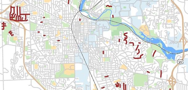
Project Limits
This project will be completed in four phases. The project is currently is Phase 2.
- Phase 1 (2024): Valley Drive/Evergreen Subdivision
- Phase 2 (2025): Kimberley, Alexandra, and Swift Run Areas
- Phase 3 (2026): North and South Geddes Area, Westover/Park Lake Area
- Phase 4 (2027): Chalmers, Elmwood, Other Areas

Map of City-maintained gravel roads. Click to enlarge map
Timeline for Phase 2
Data Collection and Public Engagement
Fall 2024-Spring 2025
Draft Recommendations (staff)
Summer/Fall 2025
Capital Plan (approved by Planning Commission)
Fall 2026
Engagement Opportunities for Phase 2
Mapping Tool
Throughout Winter 2024 and Spring 2025, residents can use this Mapping Tool to provide information about drainage concerns that they have observed in the Phase 2 project area.
Previous Engagement Opportunities
October 9, 2024 Virtual Kick-Off Meeting
Why is this project being done?
Several neighborhoods across the City of Ann Arbor have gravel roads that are experiencing drainage issues, localized flooding, and standing water.
Work To Complete for Phase 2
- Topographical survey completed via mobile lidar (vehicle equipped with a laser scanner)
- Listening session held with residents in October 2024
- Online data hub opened for public input
- Historic complaints to be reviewed and submitted to online data hub
- Technical experts, staff, and residents will walk the public right-of-way in the neighborhood in high visibility vests (construction yellow) to assess existing drainage patterns
- Identify areas for recommended drainage improvements
- Evaluate if modification of existing stormwater system is needed within the project area
- Develop strategic plans for each identified study area with a spectrum of implementable recommendations
- Final written report
Documents and Materials
Phase 1
Virtual Information Meeting, Nov. 30, 2022
Valley Drive/Evergreen Subdivision Open House, Oct. 16, 2024
